Measuring Water Use with Remote Sensing
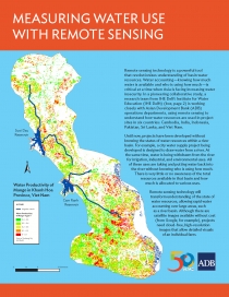
This brief discusses remote sensing technology as a powerful tool in understanding basin water resources.
In a pioneering collaborative study, a research team from IHE Delft Institute for Water Education is working closely with ADB operations departments using remote sensing to understand how water resources are used in project sites in six countries: Cambodia, India, Indonesia, Pakistan, Sri Lanka, and Viet Nam.
Using remote sensing technology, for the first time, water productivity can be measured right down to the farm level. For years, the limitation has always been the lack of data. With remote sensing technology, this will no longer be an issue.
The new window of understanding derived from this technology will be fundamental to sound planning of future water projects.

